Never say never
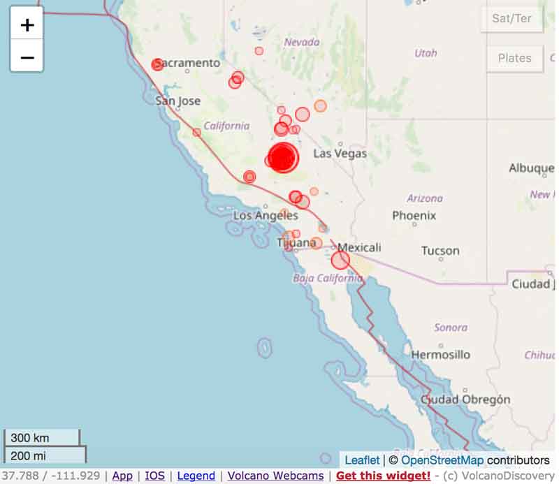
Latest earthquakes in or around California, past 30 days
Updated 9 Jul 2021 09:13 GMT -
4 minutes ago
During the past 30 days, California was shaken by 1 quake of magnitude 6.0, 1 quake of magnitude 5.2, 7 quakes between 4.0 and 5.0, 97 quakes between 3.0 and 4.0, and 370 quakes between 2.0 and 3.0. There were also 4087 quakes below magnitude 2.0 which people don't normally feel.
Biggest quake: 6.0 quake Antelope Valley, CA, 8 Jul 3:49 pm (GMT -7) 10 hours ago
Most recent quake: 2.8 quake Mono County, California, 44 mi south of Carson City, Nevada, USA, 9 July 2021 08:57 GMT 20 minutes ago
Biggest quake: 6.0 quake Antelope Valley, CA, 8 Jul 3:49 pm (GMT -7) 10 hours ago
Most recent quake: 2.8 quake Mono County, California, 44 mi south of Carson City, Nevada, USA, 9 July 2021 08:57 GMT 20 minutes ago
Date and time | Mag Depth | Nearest volcano (distance) | Location | Details | Map |
| Fri, 9 Jul 2021 (GMT) (76 earthquakes) | |||||
| 9 Jul 2021 08:57:10 GMT 20 minutes ago | 2.8 2.4 km | 76 km (47 mi) | Mono County, California, 44 mi south of Carson City, Nevada, USA I FELT IT | More | Map |
| 9 Jul 2021 08:56:38 GMT 20 minutes ago | 2.2 4.9 km | 2 Km N of Walker, California | More | Map | |
| 9 Jul 2021 08:55:10 GMT 22 minutes ago | 2.7 3.9 km | 71 km (44 mi) | Mono County, California, 47 mi south of Carson City, Nevada, USA I FELT IT - 1 report | More | Map |
| 9 Jul 2021 08:13:35 GMT 1 hour 4 minutes ago | 2.8 0.5 km | 74 km (46 mi) | Mono County, California, 46 mi south of Carson City, Nevada, USA I FELT IT - 2 reports | More | Map |
| 9 Jul 2021 08:07:02 GMT 1 hour 10 minutes ago | 2.7 0.6 km | 71 km (44 mi) | Mono County, California, 47 mi south of Carson City, Nevada, USA I FELT IT | More | Map |
| 9 Jul 2021 08:04:42 GMT 1 hour 12 minutes ago | 2.9 4.1 km | 68 km (42 mi) | Mono County, California, 49 mi south of Carson City, Nevada, USA I FELT IT | More | Map |
| 9 Jul 2021 08:01:20 GMT 1 hour 16 minutes ago | 2.8 5 km | 75 km (47 mi) | Mono County, California, 44 mi south of Carson City, Nevada, USA I FELT IT | More | Map |
| 9 Jul 2021 08:00:51 GMT 1 hour 16 minutes ago | 2.2 | 75 km (47 mi) | 1 Km ENE of Coleville, California | More | Map |
| 9 Jul 2021 07:52:31 GMT 1 hour 25 minutes ago | 2.4 0.4 km | 71 km (44 mi) | 31km SE of Markleeville, CA | More | Map |
| 9 Jul 2021 07:47:21 GMT 1 hour 30 minutes ago | ? n/a | 190 km (118 mi) | 0.3 mi northeast of Redondo Beach, Los Angeles County, California, USA (unconfirmed) I FELT IT - 3 reports | More | Map |
| 9 Jul 2021 07:44:29 GMT 1 hour 33 minutes ago | 2.0 1.7 km | 72 km (45 mi) | 3 Km W of Walker, California | More | Map |
| 9 Jul 2021 07:28:00 GMT 1 hour 49 minutes ago | 2.5 7.4 km | 34 km (21 mi) | 11 Km NW of Benton, California | More | Map |
| 9 Jul 2021 07:20:25 GMT 1 hour 57 minutes ago | 2.3 4.3 km | 71 km (44 mi) | 31km SE of Markleeville, CA | More | Map |
| 9 Jul 2021 07:20:14 GMT 1 hour 57 minutes ago | ? n/a | 154 km (96 mi) | 18 mi southeast of Modesto, Stanislaus County, California, USA (unconfirmed) I FELT IT - 4 reports | More | Map |
| 9 Jul 2021 07:19:30 GMT 1 hour 58 minutes ago | 2.6 3.7 km | 69 km (43 mi) | 31km ENE of Dardanelle, CA I FELT IT | More | Map |
| 9 Jul 2021 07:15:58 GMT 2 hours 1 minutes ago | 2.6 6.1 km | 74 km (46 mi) | 29km SE of Markleeville, CA I FELT IT | More | Map |
| 9 Jul 2021 07:14:08 GMT 2 hours 3 minutes ago | 2.7 7 km | 74 km (46 mi) | Mono County, 36 mi southeast of South Lake Tahoe, El Dorado County, California, USA I FELT IT | More | Map |
| 9 Jul 2021 07:13:02 GMT 2 hours 4 minutes ago | 2.0 1.4 km | 62 km (39 mi) | 7 Km SE of Walker, California | More | Map |
| 9 Jul 2021 07:03:18 GMT 2 hours 14 minutes ago | 2.5 5.3 km | 68 km (42 mi) | 33km SSW of Smith Valley, NV | More | Map |
| 9 Jul 2021 06:57:27 GMT 2 hours 20 minutes ago | 3.1 0.8 km | 69 km (43 mi) | Mono County, California, 49 mi south of Carson City, Nevada, USA | ||
....
g
ANOTHER REPORT:
ANOTHER REPORT:
Auch interessant: Monatliche Berichte
 Early morning on 8 July 2021, a strong magnitude 6.0 earthquake struck Little Antelope Valley, California at 3:49pm local time (July 8 at 22:49 UTC). The quake was registered at shallow depth of around 6 miles (9.8 kilometers) only.
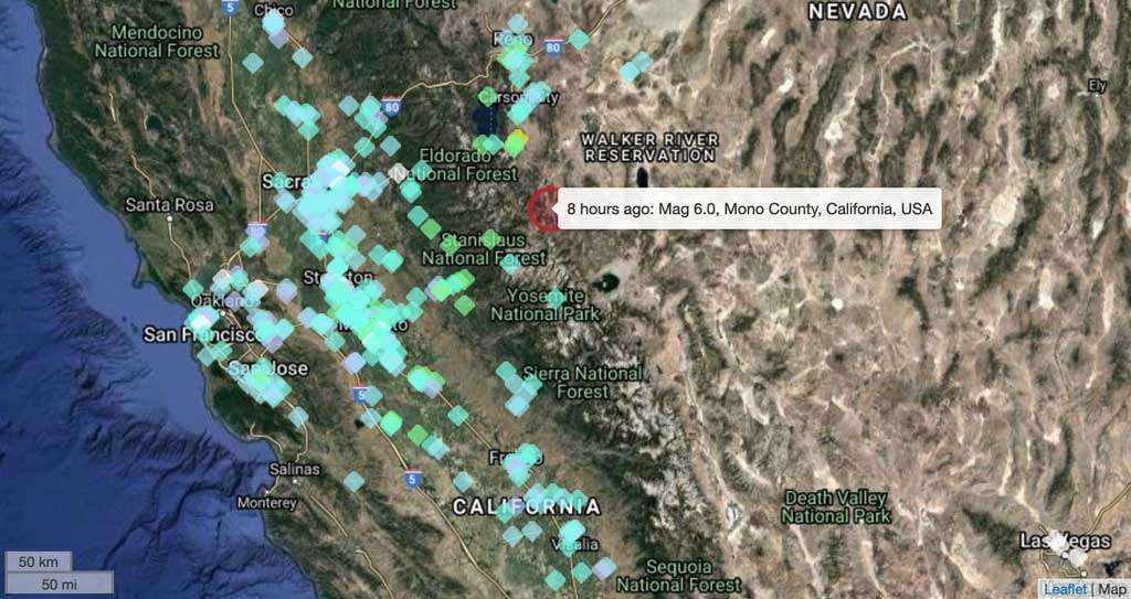
The epicenter was about 20 miles southwest of Smith Valley, NV. Perceived shaking for the quake was very strong near the epicenter and light shaking could be felt in up to hundreds of miles distance, including the SF Bay area and Las Vegas. Within minutes, hundreds of users sent reports of shaking to our monitoring service. So far, USGS has received more than 20,000 reports for this quake.
There were no immediate reports of serious damage or injuries, fortunately. Near the epicenter, things fell off shelves, windows were broken, weak walls and some roofs were damaged. Rockfalls occurred on highways near mountain slopes, with rocks hitting cars. According to local news, people were not injured.
Strong magnitude 6 quake strikes in Antelope Valley near California-Nevada border, no significant damage reported
Fr, 9. Jul 2021, 07:26
07:26 AM | VON: EARTHQUAKEMONITOR
Locations of user reports feeling this morning's quake in California
The epicenter was about 20 miles southwest of Smith Valley, NV. Perceived shaking for the quake was very strong near the epicenter and light shaking could be felt in up to hundreds of miles distance, including the SF Bay area and Las Vegas. Within minutes, hundreds of users sent reports of shaking to our monitoring service. So far, USGS has received more than 20,000 reports for this quake.
There were no immediate reports of serious damage or injuries, fortunately. Near the epicenter, things fell off shelves, windows were broken, weak walls and some roofs were damaged. Rockfalls occurred on highways near mountain slopes, with rocks hitting cars. According to local news, people were not injured.
PLEASE NOTE:
> Initial report of magnitude 4.8
Initial calculations had indicated two earthquakes striking 25 seconds but 100 miles (161 kilometers) apart. After a review, USGS removed the magnitude 4.8 quake in Farmington, about five miles (8 km) southeast of Stockton. The uncertainty was caused by the remote location, which had fewer seismic instruments,
Initial calculations had indicated two earthquakes striking 25 seconds but 100 miles (161 kilometers) apart. After a review, USGS removed the magnitude 4.8 quake in Farmington, about five miles (8 km) southeast of Stockton. The uncertainty was caused by the remote location, which had fewer seismic instruments,
Austin Elliott, a USGS geologist, explained to ABC news: “The system underestimated the original magnitude of that event and estimated a location that was slightly off from the true location,” he said.
As the seismic waves moved across the state, other stations misinterpreted them as a separate quake because ”they arrived at an unexpected time," Elliott said.
As the seismic waves moved across the state, other stations misinterpreted them as a separate quake because ”they arrived at an unexpected time," Elliott said.
> Aftershocks
Less than a minute later, a strong aftershock of magnitude 5.2 occurred in the area and nearly 100 smaller aftershocks occurred during the 8 hours since the quake, reaching magnitudes of up to 4.6. These will continue in the near future, but decrease with time. . .
Less than a minute later, a strong aftershock of magnitude 5.2 occurred in the area and nearly 100 smaller aftershocks occurred during the 8 hours since the quake, reaching magnitudes of up to 4.6. These will continue in the near future, but decrease with time. . .
Associated Press
6.0-magnitude quake rattles Northern California; no reports of damage
Quake centered near Nevada border felt as far away as San Francisco
A 5.9-magnitude earthquake struck south of Lake Tahoe, Calif., on Thursday afternoon.
Screenshot from USGSSAN FRANCISCO — An earthquake with a preliminary magnitude of 6.0 rattled the California-Nevada border Thursday afternoon, with people reporting feeling the shaking hundreds of miles away, according to the U.S. Geological Survey.
. . .The earthquake struck at 3:49 p.m. in a region about 250 miles east of San Francisco and south of Lake Tahoe. Its epicenter was 4 miles west-southwest of Walker, a California town of fewer than 900 residents. It was followed by dozens of aftershocks, with at least a half-dozen of magnitude 4.0 or greater, the USGS said.
At one point, rockslides closed about 40 miles of the interstate, a major route through the northern Sierra Nevada, authorities said. Portions of the interstate were later reopened, but crews remained at the scene in case of aftershocks, according to the California Department of Transportation.
_____________________________________________________________________________


No comments:
Post a Comment