:no_upscale()/cdn.vox-cdn.com/uploads/chorus_asset/file/22649983/usdroughtmonitor_weekly_ndmc__web__2021_06_01.png)
Amid dangerous drought conditions, we’re inviting all Utahns — regardless of religious affiliation — to join us this weekend in collective and humble prayer for rain.
— Utah Gov. Spencer J. Cox (@GovCox) June 3, 2021
Read more: https://t.co/uJzFARl7BI pic.twitter.com/HS755aXEy3
The Hoover Dam reservoir is at an all-time low
Much of the Western US faces drought, extreme heat, and fire risk
/cdn.vox-cdn.com/uploads/chorus_image/image/69433929/1253437187.0.jpg)
Lake Mead, the reservoir created by the Hoover Dam, that feeds water to 25 million people across Western states, is historically low. On June 9th, the water level dipped to 1,071.57 feet above sea level, narrowly beating a record low last set in 2016.
It didn’t help that a sweltering spring heatwave hit much of the continental US this past weekend. Las Vegas, some 30 miles from Lake Mead, reached 109 degrees Fahrenheit and could see even higher temperatures next week. Altogether, the drought and heat are scary omens for this year’s fire season. An above-normal risk of fire is forecasted for the Southwest through June, according to the National Interagency Fire Center.
In July, the Southwest’s monsoon season is expected to kick in and provide some relief — at least temporarily. Climate change has brought on higher spring and summer temperatures, more severe wildfires, less snow (which much of the West relies on for water), and more intense dry seasons.
=========================================================================
ARIZONA ( Reference: https://new.azwater.gov/drought/drought-status )
Monthly Drought Status Summary: MAY 2021
May is typically one of the two driest months in Arizona. Up to 0.50 inches of rain were received throughout Coconino, Yavapai, Gila, and Apache counties. However, this was not enough to improve current drought conditions. While north central Arizona received most of the rain, the rest of the state remained exceedingly dry, roughly 60%-90% below last year’s average precipitation levels for the month.
Drought conditions have remained largely unchanged through the month with 95% of the state in Severe (D2) to Exceptional (D4) drought.
No substantial improvement to drought is expected in June
Wildland fires continued to impact the state with above-normal fire risk. Stage 2 fire restrictions were issued on state lands in Cochise, Graham, Greenlee, Pima, Pinal, and Santa Cruz counties. All other counties continued Stage 1 fire restrictions.
May temperatures across the state were generally average for the month. The outlook for summer shows above average temperatures expected, with equal chances for above, normal, or below average amounts of rain.
This report was prepared by the Arizona Drought Monitoring Technical Committee on June 7, 2021. Arizona's short-term drought status map is updated during the first week of each month.
=========================================================================
The ...
1930s ...
ARIZONA ADEQ Monitoring and Assessment: Ambient Groundwater Monitoring Program
( Reference: https://legacy.azdeq.gov/environ/water/assessment/ambient.html )
---- NOTHING MORE RECENT THAN 2015???????????????????????????\
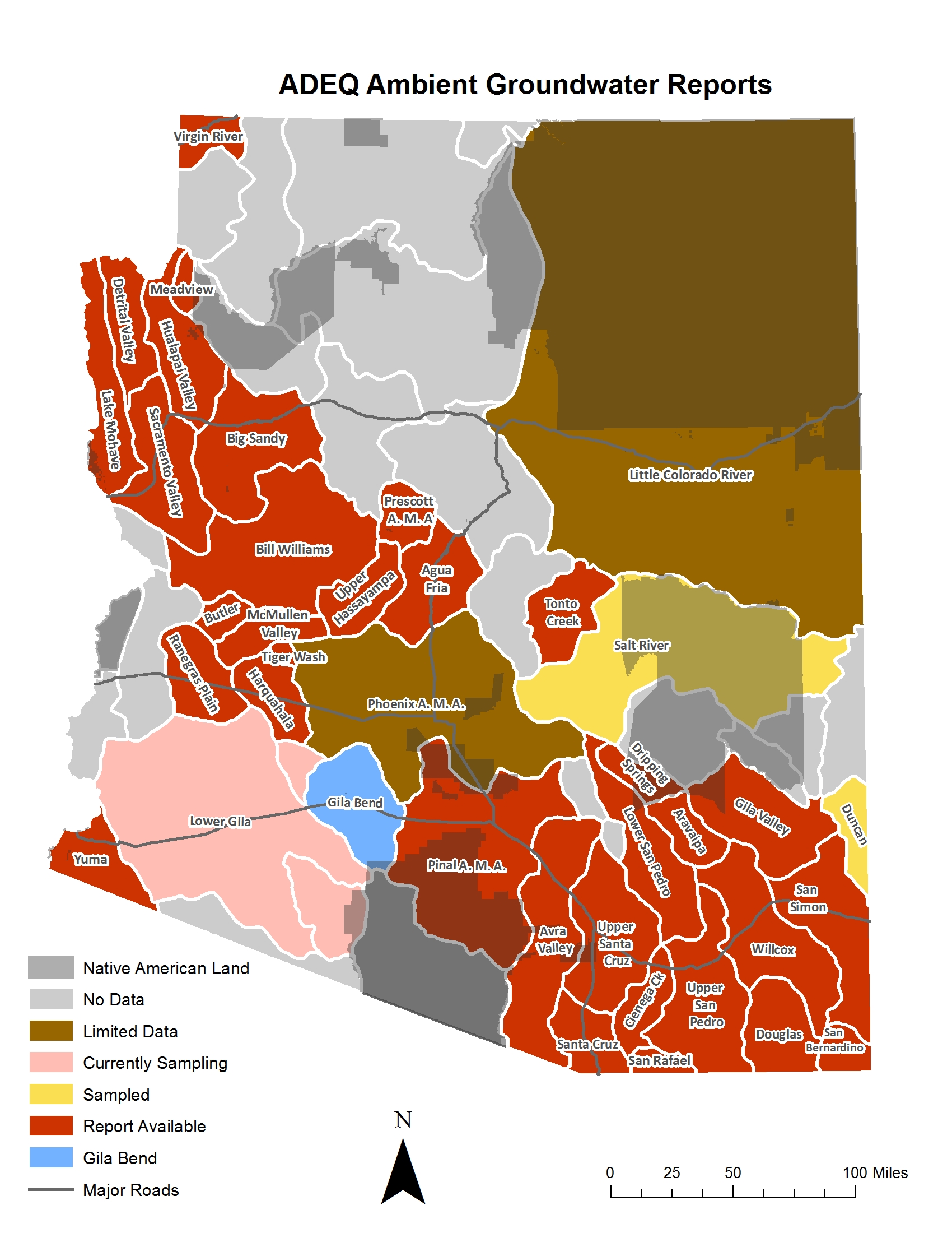
The groundwater monitoring program seeks to characterize groundwater quality in each of the 51 groundwater basins that have been designated in Arizona by state agencies. Comprehensive groundwater sampling is conducted in a basin following the approval of a sample plan. . .
The ADEQ Ambient Monitoring Program has completed reports covering 20 groundwater basins within Arizona. These reports are available in two formats: a comprehensive Open File Report (OFR) and a compact four-page fact sheet (FS). The OFR is designed for audiences seeking an indepth hydrologic analysis of the basin. In contrast, the FS is designed for a more general audience seeking a brief overview of the groundwater quality of the basin.
The data for all samples collected for these studies, besides being available in the individual OFRs are also available through the ADEQ Groundwater Database. This database includes all samples collected by the ADEQ Ambient Groundwater Monitoring Program as well as other monitoring programs within the agency.
More
Groundwater Basin Fact Sheets
- Agua Fria Basin (2004-2006) -- (PDF)
- Aravaipa Canyon Basin (2003) -- (PDF)
- Avra Valley Sub-Basin (1998-2001) -- (PDF)
- Big Sandy Basin (2003-2004) -- (PDF)
- Bill Williams Basin (2003-2009) -- (PDF)
- Butler Valley Basin (2008-2012) -- (PDF)
- Cienega Creek Basin (2000-2001) -- (PDF)
- Detrital Valley Basin (2002) -- (PDF)
- Douglas Basin (1995-1996) -- (PDF)
- Dripping Springs Wash Basin (2004-2005) -- (PDF)
- Gila Bend Basin(2012-2015) -- (PDF)
- Gila Valley Sub-Basin (2004) -- (PDF)
- Harquahala Basin (2009-2014) -- (PDF)
- Hualapai Valley Basin (2000) -- (PDF)
- Lake Mohave Basin (2003) -- (PDF)
- Lower San Pedro Basin (2000) -- (PDF)
- McMullen Valley Basin (2008-2009) -- (PDF)
- Meadview Basin (2000-2003) -- (PDF)
- Pinal Active Management Area (2005-2006) -- (PDF)
- Prescott Active Management Area (1997-1998) -- (PDF)
- Ranegras Plain Basin (2008-2011) -- (PDF)
- Sacramento Valley Groundwater Basin (1999) -- (PDF)
- San Bernardino Valley Basin (2002) -- (PDF)
- San Rafael Basin (2002) -- (PDF)
- San Simon Sub-Basin (2002) -- (PDF)
- Sierra Vista Basin (1996) (in conjunction with the USGS) -- (PDF)
- Tiger Wash Basin (2014) -- (PDF)
- Tonto Creek (2002-2012) -- (PDF)
- Upper Hassayampa Basin (2003-2009) -- (PDF)
- Virgin River Basin (1997) -- (PDF)
- Willcox Basin (1999) -- (PDF)
- Yuma Basin (1995) -- (PDF)
Groundwater Open File Reports
- Groundwater Quality in Arizona: A 15-Year Overview of the ADEQ Ambient Monitoring Program (1995-2009) -- (PDF)
- Agua Fria Basin (2004-2006) -- (PDF)
- Aravaipa Canyon Basin (2003) -- (PDF)
- Avra Valley Sub-Basin (1998-2001) -- (PDF)
- Big Sandy Basin (2003-2004) -- (PDF)
- Bill Williams Basin (2003-2009) -- (PDF)
- Butler Valley Basin (2008-2012) -- (PDF)
- Cienega Creek Basin (2000-2001) -- (PDF)
- Detrital Valley Basin (2002) -- (PDF)
- Douglas Basin (1995-1996) -- (PDF) (Download PDF Maps)
- Dripping Springs Wash Basin (2004-2005) -- (PDF)
- Fort Valley Septic Study (1997) -- (PDF)
- Gila Bend Basin (2012-2015) -- (PDF)
- Gila Valley Sub-Basin (2004) -- (PDF)
- Harquahala Basin (2009-2014) -- (PDF)
- Hualapai Valley Basin (2000) -- (PDF)
- Lake Mohave Basin (2003) -- (PDF)
- Lower San Pedro Basin (2000) -- (PDF)
- McMullen Valley Basin (2008-2009) -- (PDF)
- Meadview Basin (2000-2003) -- (PDF)
- Pinal Active Management Area (2005-2006) -- (PDF)
- Prescott Active Management Area (1997-1998) -- (PDF)
- Ranegras Plain Basin (2008-2011) -- (PDF)
- Sacramento Valley Basin (1999) -- (PDF)
- San Bernardino Valley Basin (2002) -- (PDF)
- San Rafael Basin (2002) -- (PDF)
- San Simon Sub-Basin (2002) -- (PDF)
- Sierra Vista Sub-basin/Upper San Pedro Basin (1996-1997) -- (PDF)
- Tiger Wash Basin (2014) -- (PDF)
- Tonto Creek (2002-2012) -- (PDF)
- Upper Hassayampa Basin (2003-2009) -- (PDF)
- Upper Santa Cruz Basin (1998) -- (PDF)
- Virgin River Basin (1997) -- (PDF)
- Willcox Basin (1999) -- (PDF)
- Yuma Basin (1995) -- (PDF)


No comments:
Post a Comment