Supercell thunderstorms are perhaps the most violent of all thunderstorm types, and are capable of producing damaging winds, large hail, and weak-to-violent tornadoes.
Structure and Dynamics of Supercell Thunderstorms
They are most common during the spring across the central United States when moderate-to-strong atmospheric wind fields, vertical wind shear (change in wind direction and/or speed with height), and instability are present. The degree and vertical distribution of moisture, instability, lift, and wind fields have a profound influence on convective storm type, including supercells, multicells (including squall lines and bow echoes), ordinary/pulse storms, or a combination of storm types. Once thunderstorms form, small/convective-scale interactions also influence storm type and evolution. There are variations of supercells, including "classic," "miniature," "high precipitation (HP)," and "low precipitation (LP)" storms. In general, however, the supercell class of storms is defined by a persistent rotating updraft (i.e., mesocyclone) which promotes storm organization, maintenance, and severity.
The streamwise vorticity associated with this low-level process usually is NOT evident in the environment (i.e., identifiable in a sounding). It is generated through the storm's interaction with the environment. Thus, marginal ambient wind shear may still support supercells and even tornadoes given the presence of mesoscale/storm-scale interactions, which can greatly increase the local wind shear, helicity, and therefore mesocyclone strength and tornado potential. Once shear is enhanced and maintained locally in the hook/weak echo region, a series of mesocyclones and tornadoes are possible in the vorticity-rich local environment.
Prepare for a Supercell
View the U.S. Severe Weather Map
A mesocyclone (or "meso" for short) is formed when a thunderstorm updraft meets veering winds. As the air rises in the thunderstorm, the winds will begin to twist the updraft until the whole column of air is rotating. Although each storm is different, the meso is usually found in the right rear flank of the supercell and is typically 2-6 miles wide. Technically, the mesocyclone is defined as the radar signature that appears if one is present (a yellow circle on Doppler velocity products), but you can often see the rotation with your bare eyes.

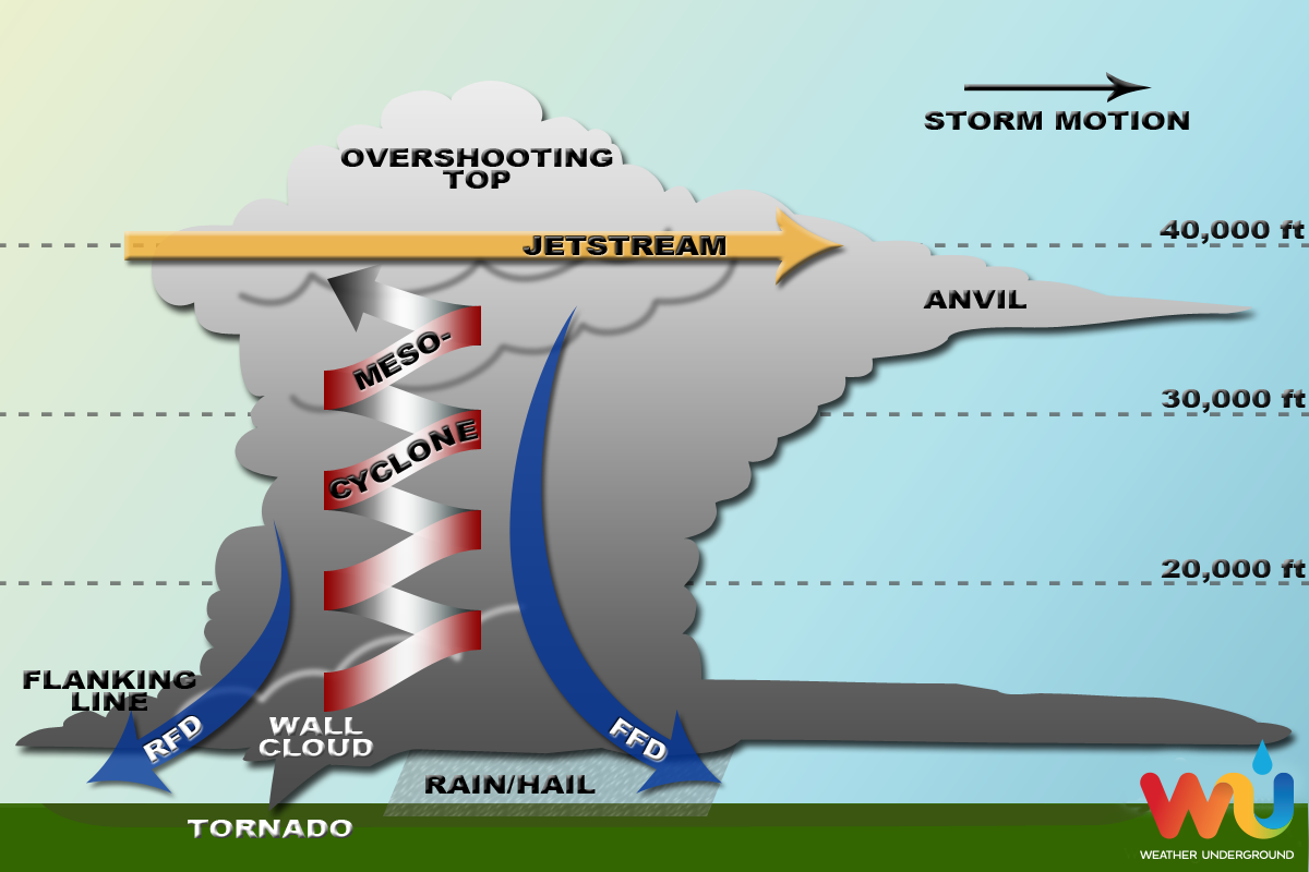
While each storm is different, most supercells usually have the following parts:
- Mesocyclone - Strong, rotating updraft
- Forward-Flank Downdraft - Cold, dense air descending through the front of the storm
- Rear-Flank Downdraft - Cold, dense air descending through the back of the storm
- Flanking Line - A line of towering cumulonimbus connected to and extending outward from the rear of the supercell
- Rain Shaft - The area in which rain and/or hail falls to the ground
- Overshooting Top - The area of clouds that "punch through" the jet stream into the lower stratosphere (occurs when updraft is particularly strong)
- Anvil - The flat layer of high cirrus clouds at the top of the storm that is shaped like an anvil, formed as the jet stream shears the updraft clouds away from the core of the storm
Types of Supercells
There are three types of supercells: low precipitation, classic and high precipitation. The definitions of these types are exactly what you would expect, but they have some different consequences.
Low Precipitation (LP) Supercells
LP supercells usually form in dry regions, where there might be just enough moisture to form the storm, but not enough moisture to rain very hard. You can usually find the updraft on the rear flank (back) of the storm, and the meso will be more defined and obvious. On radar, an LP will not show up as a hook echo because there's not enough precipitation within the storm to provide the reflectivity. These storms might not look that strong, but they can pack a punch. LP supercells often produce tornadoes and large hail.
Classic Supercells
The classic, textbook supercell looks much like the figure above. The storm will have a flat updraft base and potentially a wall cloud underneath the updraft. The precipitation (rain and hail) will fall adjacent to the updraft, usually underneath the forward flank downdraft (FFD). If the conditions are right, a tornado will form underneath the wall cloud.
High Precipitation (HP) Supercells
HP supercells usually have the updraft on the forward flank (front) of the storm, and the precip surrounds the updraft, from the FFD to the rear flank downdraft (RFD). The wall cloud and potential tornado will be "rain-wrapped" (within the "bear's cage") and difficult to observe. Rain and hail is extreme in these storms, and flash flooding usually occurs. It's possible that HP supercells are the most dangerous because of their ability to hide the warning signs of an approaching tornado.
RELATED
VIDEOS


No comments:
Post a Comment