People who live in areas with naturally high levels of arsenic in the soil and water are at particular risk. In the U.S., for example, that includes regions in the Southwest such as Arizona, Nevada and New Mexico. Additionally, human activities such as mining and agriculture can also increase arsenic in food and water sources.

Arsenic is a naturally occurring element found in the Earth’s crust. Exposure to arsenic, often through contaminated food and water, is associated with various negative health effects, including cancer.
Arsenic exposure is a global public health issue. A 2020 study estimated that up to 200 million people wordwide are exposed to arsenic-contaminated drinking water at levels above the legal limit of 10 parts per billion set by the U.S. Environmental Protection Agency and World Health Organization. More than 70 countries are affected, including the United States, Spain, Mexico, Japan, India, China, Canada, Chile, Bangladesh, Bolivia and Argentina.
Arsenic exposure is a global public health issue. A 2020 study estimated that up to 200 million people wordwide are exposed to arsenic-contaminated drinking water at levels above the legal limit of 10 parts per billion set by the U.S. Environmental Protection Agency and World Health Organization. More than 70 countries are affected, including the United States, Spain, Mexico, Japan, India, China, Canada, Chile, Bangladesh, Bolivia and Argentina.
erica's water crisis
A series on the challenges many in the US face getting access to safe, clean, affordable water, and the injustices to those most at risk


Global threat of arsenic in groundwater
Dowsing for danger
Arsenic is a metabolic poison that is present in minute quantities in most rock materials and, under certain natural conditions, can accumulate in aquifers and cause adverse health effects. Podgorski and Berg used measurements of arsenic in groundwater from ∼80 previous studies to train a machine-learning model with globally continuous predictor variables, including climate, soil, and topography (see the Perspective by Zheng). The output global map reveals the potential for hazard from arsenic contamination in groundwater, even in many places where there are sparse or no reported measurements. The highest-risk regions include areas of southern and central Asia and South America. Understanding arsenic hazard is especially essential in areas facing current or future water insecurity.
Abstract
Naturally occurring arsenic in groundwater affects millions of people worldwide. We created a global prediction map of groundwater arsenic exceeding 10 micrograms per liter using a random forest machine-learning model based on 11 geospatial environmental parameters and more than 50,000 aggregated data points of measured groundwater arsenic concentration. Our global prediction map includes known arsenic-affected areas and previously undocumented areas of concern. By combining the global arsenic prediction model with household groundwater-usage statistics, we estimate that 94 million to 220 million people are potentially exposed to high arsenic concentrations in groundwater, the vast majority (94%) being in Asia. Because groundwater is increasingly used to support growing populations and buffer against water scarcity due to changing climate, this work is important to raise awareness, identify areas for safe wells, and help prioritize testing.
The natural, or geogenic, occurrence of arsenic in groundwater is a global problem with wide-ranging health effects for humans and wildlife. Because it is toxic and does not serve any beneficial metabolic function, inorganic arsenic (the species present in groundwater) can lead to disorders of the skin and vascular and nervous systems, as well as cancer (1, 2). The major source of inorganic arsenic in the diet is through arsenic-contaminated water, although ingestion through food, particularly rice, represents another important route of exposure (3). As a consequence, the World Health Organization (WHO) has set a guideline arsenic concentration of 10 μg/liter in drinking water (4).
At least trace amounts of arsenic occur in virtually all rocks and sediments around the world (5). However, in most of the large-scale cases of geogenic arsenic contamination in groundwater, arsenic accumulates in aquifers composed of recently deposited alluvial sediments. Under anoxic conditions, arsenic is released from the microbial and/or chemical reductive dissolution of arsenic-bearing iron(III) minerals in the aquifer sediments (6–9). Under oxidizing, high-pH conditions, arsenic can also desorb from iron and aluminum hydroxides (10). Furthermore, aquifers in flat-lying sedimentary sequences generally have a small hydraulic gradient, causing groundwater to flow slowly. This longer groundwater residence time allows dissolved arsenic to accumulate and its concentration to increase. Other processes responsible for arsenic release into groundwater include oxidation of arsenic-bearing sulfide minerals as well as release from arsenic-enriched geothermal deposits.
That arsenic is generally not included in the standard suite of tested water quality parameters (11) and is not detected by the human senses means that arsenic is regularly being discovered in new areas. Since one of the greatest occurrences of geogenic groundwater arsenic was discovered in 1993 in the Bengal delta (5, 12, 13), high arsenic concentrations have been detected all around the world, with hot spots including Argentina (14–17), Cambodia (18, 19), China (20–22), India (23–25), Mexico (26, 27), Pakistan (28, 29), the United States (30, 31), and Vietnam (32, 33).
To help identify areas likely to contain high concentrations of arsenic in groundwater, several researchers have used statistical learning methods to create arsenic prediction maps based on available datasets of measured arsenic concentrations and relevant geospatial parameters. Previous studies have focused on Burkina Faso (34), China (21, 35), South Asia (29, 36), Southeast Asia (37), the United States (31, 38, 39), and the Red River delta in Vietnam (33), as well as sedimentary basins around the world (40). The predictor variables used in these studies generally include various climate and soil parameters, geology, and topography (table S3).
Taking advantage of the increasing availability of high-resolution datasets of relevant environmental parameters, we use statistical learning to model what to our knowledge is the most spatially extensive compilation of arsenic measurements in groundwater assembled, which makes a global model possible. To focus on health risks, we consider the probability of arsenic in groundwater exceeding the WHO guideline. For this, we have chosen the random forest method, which our preliminary tests showed to be highly effective in addressing this classification problem. We use the resulting model to produce the most accurate and detailed global prediction map to date of geogenic groundwater arsenic, which can be used to help identify previously unknown areas of arsenic contamination as well as more clearly delineate the scope of this global problem and considerably increase awareness.
Results
Random forest modeling
We aggregated data from nearly 80 studies of arsenic in groundwater (see table S1 for references and statistics) into a single dataset (n > 200,000). Averaging into 1-km2 pixels resulted in more than 55,000 arsenic data points for use in modeling based on groundwater samples not known to originate from greater than 100-m depth (Fig. 1).


_________________________________________________________________________
Arsenic Exposure via Contaminated Water and Food Sources


Received: 23 May 2022 / Revised: 7 June 2022 / Accepted: 8 June 2022 / Published: 11 June 2022
(This article belongs to the Special Issue Sustainable Approaches in Water Treatment Practices, Presenting Minimum Environmental Impact)
Abstract
Arsenic poisoning constitutes a major threat to humans, causing various health problems. Almost everywhere across the world certain “hotspots” have been detected, putting in danger the local populations, due to the potential consumption of water or food contaminated with elevated concentrations of arsenic. According to the relevant studies, Asia shows the highest percentage of significantly contaminated sites, followed by North America, Europe, Africa, South America and Oceania. The presence of arsenic in ecosystems can originate from several natural or anthropogenic activities. Arsenic can be then gradually accumulated in different food sources, such as vegetables, rice and other crops, but also in seafood, etc., and in water sources (mainly in groundwater, but also to a lesser extent in surface water), potentially used as drinking-water supplies, provoking their contamination and therefore potential health problems to the consumers. This review reports the major areas worldwide that present elevated arsenic concentrations in food and water sources. Furthermore, it also discusses the sources of arsenic contamination at these sites, as well as selected treatment technologies, aiming to remove this pollutant mainly from the contaminated waters and thus the reduction and prevention of population towards arsenic exposure.
Figure 1 shows the various routes of arsenic and arsenic-related compounds that can accumulate in an ecosystem due to anthropogenic activities, resulting in environmental deterioration.
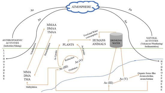
Figure 1. Pathways through which arsenic and its relevant compounds may enter the environment and contaminate soil, atmosphere and water. Human and natural activities result in As accumulation, mainly in soil and water, where As(V) and As(III) are interconverted via oxidation and reduction bio/reactions. The respective methylated products can be produced from As(III) species, i.e., MMA, DMA and TMA, resulting in the formation of MMAA, DMAA and TMAA chemical compounds, mainly through volatilization, while the reverse process occurs through demethylation.
7. Conclusions
Arsenic concentration in food and drinking water above the maximum permissible concentration limit is a common water pollution problem in both developed and developing countries.
- The exposure to higher concentrations of arsenic may be life threatening.
- Water sources for drinking, such as surface water or groundwater, and food sources, such as fish, crops and cereals, can play a notorious role in exposing humans to arsenic.
- According to the literature, intense arsenic contamination is mainly attributed to mining and erosion activities, affecting mainly groundwater and surface water.
- By using arsenic-contaminated water for irrigation, the pollution problem can be transferred to the produced vegetation. In this case, most studies are focused on rice, as this crop requires large amounts of water for cultivation and,
- in addition, it is consumed in large quantities in highly populated areas.
- Similarly, through water, arsenic can accumulate in fish, mainly from freshwaters, and in other marine species, especially mussels.
- Taking into account these problems, the continuous monitoring of arsenic levels in water and food sources is mandatory in the future, allowing the application of proper treatment/removal process and the prevention of humans from arsenic intake.
REFERENCE: MDPI
__________________________________________________________________________


_


 with unusual flight characteristics. <em>Marc Cecotti/Adam Keyhoe/The War Zone</em>")
 and MOAs (outlined in purple) used for military training in Arizona and neighboring states. <em>DOD</em>")
 zones. <em>VFRmap.com</em>")


.png)


