 ^ Now please take a look at the concentration and high density of dots in the upper-right corner of the enlarged cropping from the map shown to the left - the word MORONI (the name of an angel from The Book of Mormon) is appended to the Spanish word Pueblo in a section of concentrations of centuries-old settlements with "many small reservoirs and temples". Places of worship. sacred ground - clearly marked on this historic map.
_________________________________________________________________________
What is your MesaZona blogger getting at focusing on just that one word temples?
Simply because it's not unusual for one civilization or culture to attempt to bury or cover over signs of earlier cultures, physically removing from sight or building structures on top of the sites of earlier cultures.
featured top story
A canal runs through it: city site’s new challenge
"All the buildings on a city-owned vacant lot near downtown Mesa have been cleared in preparation for long-sought development, but an archaeological consultant thinks the site could still hold Mesa history and prehistory underground.
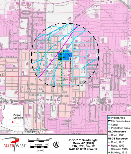
As part of city development partner Miravista Holdings’ master planning process for the development of the so-called Transform 17 site, Phoenix-based archaeology firm PaleoWest reviewed historic documentation of the area and issued a report on the site’s historical features.
PaleoWest tried to assess what cultural resources might still exist beneath the lot before construction crews potentially disturb it if the city and Miravista sign off on a final development agreement in August for the 27-acre site just north of Main Street near Phoenix Marriott Mesa.
It studied historic maps and scoured databases of previous archaeological and historic research within the site and a half-mile radius around it.
PaleoWest believes its study is the first cultural resource survey of the Transform 17 site, which is within the original Mesa townsite and less than a mile from the Mesa Grande pueblo... PaleoWest found reasons to believe “significant information on the prehistoric occupation in the Phoenix Basin or on the early residents and development of the Town of Mesa“ may still be preserved beneath the former home sites...the historic development could have had the effect of preserving subsurface prehistoric resources that may have been present in the Project area. [that may have] survived the demolition of the residential structures.”
. . .Sampling can give archaeologists an idea of what’s beneath a site without excavating the whole area.
One important factor for Miller’s recommendation is the presence of a prehistoric canal running through the site diagonally from northeast to southwest. This would have brought Salt River water to agricultural fields during the Hohokam period, from 500 A.D. to 1400 A.D., when ancestral desert farmers made the Salt River valley bloom.
The canal is no longer evident on the parcel’s surface, but Miller wrote that evidence of it could still exist below the surface. He recommended that archaeologists focus test digs along “the mapped alignment of the prehistoric canal” to see what clues remain.
. . .Old maps reveal other interesting things about Transform 17’s past.
> On an 1870 federal General Land Office map, PaleoWest identified a road running southwest-northeast just outside Transform 17. On the map, the road is labeled “Maricopa Wells to Fort McDowell.” Fort McDowell was an important hub for American settlement in the mid 1800s, and Maricopa Wells was a stop along the Southern Emigrant Trail.
> A railroad circa 1913 passed through the site, though no clues of it remain on the surface.
Neil Calfee a representative with Miravista Holdings, said the company has “not yet undertaken any testing or mitigation measures related to site archeology. Our current efforts are focused on completing our entitlement process and finalizing our development agreement with the city. . ."
> Vic Linoff, a local historian and president of the nonprofit Mesa Preservation Foundation, said he hopes the city and Miravista are diligent about following PaleoWest’s recommendations...it was especially important to record the past at Transform 17 given “the very sad chapter, I think, in the city’s history” related to the acquisition of the property. . .
> To sell its recommendation to conduct an archaeological study before starting construction of the new development, PaleoWest’s report emphasizes the potential prehistoric and Territorial period history of the site, but Linoff thinks Transform 17’s later history as a place where marginalized Mesans could make a home is also important. . ."
Tags
Read more >>


No comments:
Post a Comment